Update 12 Feb 2021 Added Bonus Pics of Trigg Island courtesy of Chris Holyday author ‘Between Beach and Bush’ book.
Trigg suburb and the
small island off the coast in this area were named after Henry Trigg,
Superintendent of Public Works for the Swan River Colony in 1842.
In 1919 there were
only 3 buildings in the locality, and holiday and fishing shacks begin to
appear in the 1920s.
Trigg
eventually started to be formally developed in the late 1940s, when 1,888 lots
were subdivided and sold. Many of the streets in the area were named after
former residents and pioneers, as well as local personalities. Source City of Stirling.
Trigg Point
In the summertime the quality of Trigg Point waves is dependent on the south westerly sea breezes moving sand from Scarborough and beyond to the reef area at TP. At the end of summer, northerly winds move the sand back to the Scarborough region.
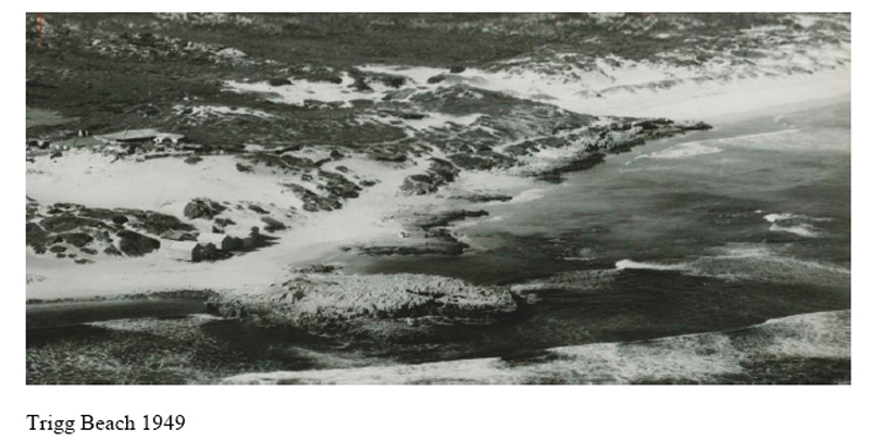
The following photo taken in 1949 shows exposed coastal reef and undeveloped land at Trigg Point. Judging by the lack of beach sand it was probably taken during the winter season.
1949 Aerial shot of reef formation at Trigg Point. Photographer unknown. Late 50s beach shacks & new Trigg Island SLSC at Trigg Point. City of Stirling pic courtesy of Chris Holyday editor Coast Whispers – Trigg, North Beach, Watermans Bay 1964 Aerial view of Trigg Point in early spring. Jim Breadsell pic. 1964 Trigg Point beach with boat shacks near Trigg Island. Jim Breadsell pic
The waves at Trigg Point attract the biggest crowd in the metro area, but has the wave shape and length of ride changed over the years?
Man-made changes to natural beach formations at Trigg Beach for beach safety and erosion reasons, may have impacted on the annual sand movement and wave quality at Trigg Point.
Trigg’s old-timers talk of sections of the reef near the
‘Blue Hole’ and in front of the Trigg SLSC being blown up in the 80s.
1984 Crowd chaos at Trigg Point. Paul Hardie pic 2007 Trigg Point line-up. Photographer unknown.
Man-made changes at neighbouring beaches south of Trigg, may also be impacting on the annual sand movement to TP.
Scarborough beach
Tom Blaxell (WA Surf Industry pioneer and Scarborough surfer). “I remember the setup on the massive sand beach at Scarborough in the 60s, before the Authorities put in the artificial vegetated dunes, which were installed to control the seasonal sand drift, which used to clog up the carpark, and I think to help against beach erosion.
As a consequence, it seems that the underlying reefs, like Three Penny Reef, and even Trigg Blue Hole don’t get exposed nearly as much as they used to, in winter in the old days. The Rocky bluff that stands at Trigg Point used to separate from the beach in winter, hence it used to be called Trigg Island (the SLSC Club is still called that), but which has now become known as Trigg Point.
I remember around 1980 the City of
Stirling working out that the beach at Trigg Point was growing by about half a
metre per year. As a result, the point has become less of a point than it used
to be.
The following image shows the vast white sand beach prior to the implementation of artificial vegetated dunes circa 1983. That’s the Brighton drain outlet in the foreground (right). Sometimes that turned into a river like at Smiths Beach Yallingup”.
1966 Aerial view of wide sandy beach at Scarborough & Brighton beaches prior to sand restoration work. Jim Breadsell pic
Brighton beach
A section of reef at Brighton beach (south of Scarborough) was blown up by the army after drownings in the area in the 1920s. Source City of Stirling history.
1963 Brighton beach with beach shelters and night lights looking north towards Scarborough & Trigg. Brighton drain is in the foreground. Murray D’Arcy pic.
Tom
Blaxell – “I
think we all have memories of the best waves, usually in the past.
It’s
hard to be precise in these things, and certainly seasonal sand movements and
aggregations are a rough science.
But
certainly, the City of Stirling thrust was to build up and stabilise the sand
aggregation, to reduce erosion & coastal damage in winter, when a lot of it
got washed away.
I
used to be on their Coastal advisory committee, chipping in viewpoints from a
surfer’s angle, but I’ve got to say their strategy has worked, from their
angle.
The beach line does seem to be more stable than it was in the old days. As a result, I believe that the coastline sand formation is generally straighter, with less irregularities & peaks. So yes, it could be the case that there is a lowering of quality for surfing these days, compared to the original natural formation”.
1990 Trigg Point Board Riders team photo at TP. Tom Blaxell in Akubra hat. Tom Blaxell pic 1996 Trigg Point Board Riders ‘A’ Team. Tom Blaxell in Santa cap. Tom Blaxell pic
It’s debatable whether changes to the annual sand movement and wave quality at Trigg Point is due to man’s intervention of the natural beach process or Mother Nature (who is a very fickle lady) changing weather patterns.
It would be interesting if there is scientific evidence of any changes in wave quality at TP.
Bonus Pics
1930s Trigg Island coast road looking south towards Trigg Island & beach shacks. Courtesy of City of Stirling Collection 1960s Trigg Island coast road looking north towards Nun’s Pool from the Point car park. Westpix courtesy of Nichola Smith administrator Westralian Life Before 2000 Face Book.
Thanks Tom Blaxell and the other contributors for sharing your beach history material.
Update 12 Feb 2021 Added Bonus Pics of Trigg Island courtesy of Chris Holyday author ‘Between Beach and Bush’ book.
Trigg suburb and the small island off the coast in this area were named after Henry Trigg, Superintendent of Public Works for the Swan River Colony in 1842.
In 1919 there were only 3 buildings in the locality, and holiday and fishing shacks begin to appear in the 1920s.
Trigg eventually started to be formally developed in the late 1940s, when 1,888 lots were subdivided and sold. Many of the streets in the area were named after former residents and pioneers, as well as local personalities. Source City of Stirling.
Trigg Point
In the summertime the quality of Trigg Point waves is dependent on the south westerly sea breezes moving sand from Scarborough and beyond to the reef area at TP. At the end of summer, northerly winds move the sand back to the Scarborough region.
The following photo taken in 1949 shows exposed coastal reef and undeveloped land at Trigg Point. Judging by the lack of beach sand it was probably taken during the winter season.
The waves at Trigg Point attract the biggest crowd in the metro area, but has the wave shape and length of ride changed over the years?
Man-made changes to natural beach formations at Trigg Beach for beach safety and erosion reasons, may have impacted on the annual sand movement and wave quality at Trigg Point.
Trigg’s old-timers talk of sections of the reef near the ‘Blue Hole’ and in front of the Trigg SLSC being blown up in the 80s.
Man-made changes at neighbouring beaches south of Trigg, may also be impacting on the annual sand movement to TP.
Scarborough beach
Tom Blaxell (WA Surf Industry pioneer and Scarborough surfer). “I remember the setup on the massive sand beach at Scarborough in the 60s, before the Authorities put in the artificial vegetated dunes, which were installed to control the seasonal sand drift, which used to clog up the carpark, and I think to help against beach erosion.
As a consequence, it seems that the underlying reefs, like Three Penny Reef, and even Trigg Blue Hole don’t get exposed nearly as much as they used to, in winter in the old days. The Rocky bluff that stands at Trigg Point used to separate from the beach in winter, hence it used to be called Trigg Island (the SLSC Club is still called that), but which has now become known as Trigg Point.
I remember around 1980 the City of Stirling working out that the beach at Trigg Point was growing by about half a metre per year. As a result, the point has become less of a point than it used to be.
The following image shows the vast white sand beach prior to the implementation of artificial vegetated dunes circa 1983. That’s the Brighton drain outlet in the foreground (right). Sometimes that turned into a river like at Smiths Beach Yallingup”.
Brighton beach
A section of reef at Brighton beach (south of Scarborough) was blown up by the army after drownings in the area in the 1920s. Source City of Stirling history.
Tom Blaxell – “I think we all have memories of the best waves, usually in the past.
It’s hard to be precise in these things, and certainly seasonal sand movements and aggregations are a rough science.
But certainly, the City of Stirling thrust was to build up and stabilise the sand aggregation, to reduce erosion & coastal damage in winter, when a lot of it got washed away.
I used to be on their Coastal advisory committee, chipping in viewpoints from a surfer’s angle, but I’ve got to say their strategy has worked, from their angle.
The beach line does seem to be more stable than it was in the old days. As a result, I believe that the coastline sand formation is generally straighter, with less irregularities & peaks. So yes, it could be the case that there is a lowering of quality for surfing these days, compared to the original natural formation”.
It’s debatable whether changes to the annual sand movement and wave quality at Trigg Point is due to man’s intervention of the natural beach process or Mother Nature (who is a very fickle lady) changing weather patterns.
It would be interesting if there is scientific evidence of any changes in wave quality at TP.
Bonus Pics
Thanks Tom Blaxell and the other contributors for sharing your beach history material.
————————————————-
Share this:
Like this: